Energy is at the center of developing economies and essential for the development of the world. Current energy systems are unfortunately unable to meet the increasing demand that is rising exponentially. To ensure a reliable source of energy, Governments and private entities are investing in geophysical services and technologies to ensure the provision of adequate energy security. A geophysical survey is a cost-effective and reliable method to investigate the subsurface level of Earth and for the exploration of metals, minerals and energy sources such as oil and gas. These do not require drilling, optimizing the exploration program and maximizing the rate of ground coverage while minimizing the use of drilling.
A geophysical services company specializes in locating and measuring the amounts of resources such as minerals, metals, oil and gas. The rising value of the investment in petroleum and gas exploration is augmented by the increasing demand for energy resources in certain countries. It has led to the robust growth of industry over the last few years. Therefore, geophysical surveys are employe in the initial stages to map the mineral ore surroundings and identify specific mineralize zones. In the final stages of exploration, detail geophysical surveys are use for delineation of mineral ore and to estimate how much reserve is there in a particular mine. To do this, several methods are use, each with its unique advantages and suitability. Three of the most common methods of geophysical service companies are list below.
Induced Polarization (IP)
This is an extensively use method in mineral exploration and mines operations. The survey is similar to electrical resistivity tomography and is apply on the ground surface using multiple four-electrode sites. This method is use to measure the electrical properties of the subsurface rock. Electrodes are use to inject electrical current into the ground, energizing it. Induce polarization represents the ability of the rock to briefly hold an electrical charge after the electrically charge is turn off. By measuring the electrical gradient between receiver electrodes, the apparent resistivity of the ground is calculate.
The survey depth and resolution are adjust by increasing or decreasing the spacing of the electrodes. Depending on what parameters are target, different IP survey configurations are deploy. Determining the electrical properties of the rocks provides clues in determining the subsurface potential for finding minerals. The measured electrical properties reveal essential information about geology, structure, and mineralization, while the increase in IP indicates the increase in polarizable materials.
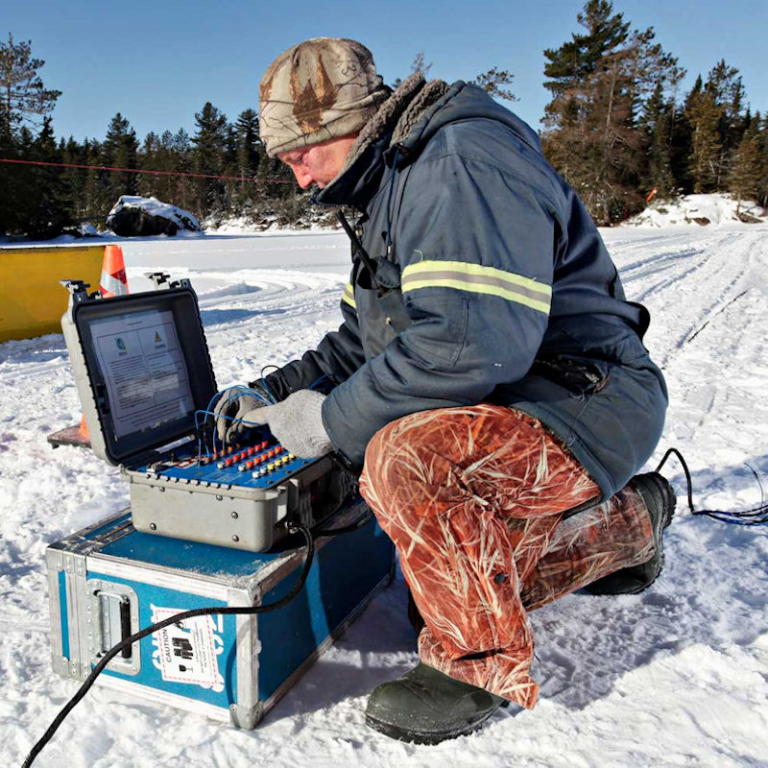
3D Distributed Array IP
This is perhaps the most technologically advance IP service available to the mineral exploration industry. Distribution array surveys are recommend for complex and anisotropic targets where the surface resolution has a lower priority. Due to the advances made in hardware technology, it is now possible to acquire large quantities of data in a short time. This particular system employs multiple full-waveform 2 channel receivers that are deploy with random dipole lengths and orientations. Throughout the survey area base on the targeting needs.
Random current is inject throughout the survey area, allowing concurrent resistivity and chargeability measurements in multiple directions, configurations and depths. When the data set is process, the resulting observations provide ten times. The data points in multiple directions than a 2D IP survey. The extensive information acquired undergoes a 3D inversion to give a full three-dimensional model of the chargeability and resistivity results. The dipole does not have to be linear as this method is 100% GPS base, and the deployment of the array can be designe to fit any kind of terrain. And has minimal impact in environmentally and culturally sensitive areas.
Magnetometer
It is a geophysical instrument for measuring the strength and direction of the magnetic field and is use to calibrate electromagnet and permanent magnets to determine the magnetization of materials. It is known that every mineral exhibits a unique magnetic susceptibility. Different geological units below the ground cause local disturbances within the magnetic field. What a magnetometer does is measure peak magnetic disturbances known as anomalies. Processing the magnetic variations allows the magnetic anomalies to be better visualize and reference. Magnetometer uses a single sensor to measure the total magnetic field strength or may sometimes use spatially separated sensors to measure the gradient of the magnetic field. As the distance between the source and sensor increases, the resolution drops and the shorter wavelengths are lost. Therefore, ground-based systems prove to be more advantageous depending on the target.
Other methods deployed by mineral exploration companies and geophysical service companies serve different purposes. However, these are three of the most advanced and most used techniques. Different versions and configurations of these methods are also employe for specific needs as these are highly customizable methods. When used in combination with different technologies, these methods provide excellent and accurate results that are helpful in mineral exploration.